


![BlueChart g2 Vision - VEU706L - UK-Ireland-The Netherlands 2014.0 [15.50]](https://www.hostdel.com/banners/Hosting/728x90.gif)
Results 1 to 10 of 13
Threaded View


-
22nd March 2014, 11:55 PM #1
 Garmin Master

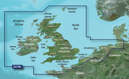
 BlueChart g2 Vision - VEU706L - UK-Ireland-The Netherlands 2014.0 [15.50]
BlueChart g2 Vision - VEU706L - UK-Ireland-The Netherlands 2014.0 (15.50)
Part Number: MicroSD/SD (010-C0853-00), Download (010-D0433-00)
See your vessel’s precise, on-chart position in relation to navaids, coastal features and restricted areas with premium features found in this detailed marine mapping data. Includes all of the features of our BlueChart® g2 product, plus 3-D perspective above and below the waterline, Auto Guidance, high-resolution imagery, and aerial photos of ports, harbors, marinas and landmarks.
- Shaded depth contours, coastlines, spot soundings, navaids, port plans, wrecks, obstructions, intertidal zones, restricted areas and IALA symbols.
- Seamless transitions between zoom levels and more continuity across chart boundaries.
- High resolution satellite imagery for a realistic view of the land and water.
- Aerial photos of ports, harbors, marinas, waterways, navigational landmarks and other POIs.
- Auto Guidance technology searches chart data to suggest the best passage to a destination.
- MarinerEye view 3-D perspective for a quick, easy position fix.
- FishEye view 3-D perspective for an underwater view of the sea floor.
- Safety Shading* enables contour shading for all depth contours shallower than your defined safe depths.
- Fishing Charts* to scope out bottom contours and depth soundings with less visual clutter on the display.
- Plan and organize routes from your computer with HomePort™ (sold separately).
Coverage
Detailed coverage of the British Isles in their entirety, including the Thames Estuary, Caledonian Canal, Outer Hebrides, Shetland and Orkney Islands, Isle of Wight, Isle of Man, Lough Neagh and the Irish Sea. Continental coverage from Brest, FR to Kiel, DE including the Channel Islands, the Waddenzee, the IJsselmeer, the canals of The Netherlands, the Meuse River to Liege, BE; the Rhine River to Dusseldorf, DE and the Kiel Canal. Detailed coverage of ports include London and Liverpool, UK; Antwerp, BE; Rotterdam and Amsterdam, NE; Calais, FR and Hamburg, DE.
FID: 3248, PID: 1, RID: 4, VID: 12
Locked Image:
UnLocked Image:
 p33dro Reviewed by p33dro on . BlueChart g2 Vision - VEU706L - UK-Ireland-The Netherlands 2014.0 [15.50] BlueChart g2 Vision - VEU706L - UK-Ireland-The Netherlands 2014.0 (15.50) Part Number: MicroSD/SD (010-C0853-00), Download (010-D0433-00) See your vessel’s precise, on-chart position in relation to navaids, coastal features and restricted areas with premium features found in this detailed marine mapping data. Includes all of the features of our BlueChart® g2 product, plus 3-D perspective above and below the waterline, Auto Guidance, high-resolution imagery, and aerial photos of ports, Rating: 5When nothing goes right, go left.
-
The Following 1 Users Say Thank You to p33dro For This Useful Post:
- [ Click To Expand ]
-
zeilgraag (25th May 2014)
![BlueChart g2 Vision - VEU706L - UK-Ireland-The Netherlands 2014.0 [15.50]](https://www.hostdel.com/banners/RDP/300X250.gif)

 Register To Reply
Advertisements
![BlueChart g2 Vision - VEU706L - UK-Ireland-The Netherlands 2014.0 [15.50]](https://www.hostdel.com/banners/Dedicated/728x90.gif)
Suggested Articles:
![BlueChart g2 Vision - VEU706L - UK-Ireland-The Netherlands 2014.0 [15.50]](https://www.hostdel.com/banners/GameServer/728x90.gif)
Similar Threads
-
BlueChart g2 Vision - VRU002R-Black Sea & Azov Sea 2014.0 [15.50]
By p33dro in forum Garmin ArchivesReplies: 6Last Post: 31st October 2022, 02:54 PM -
BlueChart g2 Vision - VEU717L - East Mediterranean & Black Sea 2014.0 [15.50]
By p33dro in forum Garmin MapsReplies: 4Last Post: 28th March 2021, 05:31 AM -
BlueChart g2 Vision - VEU714L - Iberian Pen.-Azores-Canaries 2014.0 [15.50]
By p33dro in forum Garmin ArchivesReplies: 4Last Post: 4th August 2020, 09:34 PM -
BlueChart g2 - HEU706L - UK-Ireland-The Netherlands 2014.0 [15.50]
By p33dro in forum Garmin ArchivesReplies: 0Last Post: 22nd March 2014, 10:32 PM -
BlueChart g2 - HEU706L - UK-Ireland-The Netherlands 2014.0 [15.50]
By p33dro in forum Garmin MapsReplies: 0Last Post: 22nd March 2014, 10:32 PM

![BlueChart g2 Vision - VEU706L - UK-Ireland-The Netherlands 2014.0 [15.50]](https://www.hostdel.com/banners/Email/300X250.gif)


 Staff Online
![BlueChart g2 Vision - VEU706L - UK-Ireland-The Netherlands 2014.0 [15.50]](https://www.hostdel.com/banners/Dedicated/300x600.gif)
high-level-c-automotive [or some...
Hi, I'm afraid there is not another solution...