


![BlueChart g2 - HAF003R - Western Africa 2014.5 [16.00]](https://www.hostdel.com/banners/Hosting/728x90.gif)
Results 1 to 4 of 4
-
19th March 2015, 12:15 AM #1
 Garmin Expert
Supporter

 BlueChart g2 - HAF003R - Western Africa 2014.5 [16.00]
BlueChart g2 - HAF003R - Western Africa 2014.5 (16.00)
See your vessels precise, on-chart position in relation to navaids, coastal features, anchorages, obstructions, waterways, restricted areas and more with this detailed marine mapping data.
- Shaded depth contours, coastlines, spot soundings, navaids, port plans, wrecks, obstructions, intertidal zones, restricted areas and IALA symbols.
- Seamless transitions between zoom levels and more continuity across chart boundaries.
- Standard 2-D direct overhead or 3-D over the bow map perspective for easy chart reading and orientation.
- Safety Shading* enables contour shading for all depth contours shallower than your defined safe depths.
- Fishing Charts* to scope out bottom contours and depth soundings with less visual clutter on the display.
- Plan and organize routes from your computer with HomePort (sold separately).
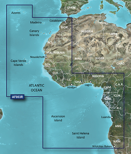
Coverage
General coverage of the west coast of Africa from El Aaraich, Mor. to Cape Cross, Nam., including Abidjan, C.I., Douala, Cam. and Luanda, Ang. Included in this overall general coverage are a number of detailed charts covering areas such as Casablanca, Mor., Dakar, Sen., and Lagos, Nig. Also includes general coverage of St. Helena Is., Ascension Is., and the Azores. Also includes detailed coverage of the Madeira Islands, Canary Islands, and Cape Verde Islands.
FID: 3490, PID: 1, RID: 2, VID: 3
Locked Image:
UnLocked Image:
 PiEtU Reviewed by PiEtU on . BlueChart g2 - HAF003R - Western Africa 2014.5 [16.00] BlueChart g2 - HAF003R - Western Africa 2014.5 (16.00) See your vessels precise, on-chart position in relation to navaids, coastal features, anchorages, obstructions, waterways, restricted areas and more with this detailed marine mapping data. Shaded depth contours, coastlines, spot soundings, navaids, port plans, wrecks, obstructions, intertidal zones, restricted areas and IALA symbols. Seamless transitions between zoom levels and more continuity across chart boundaries. Rating: 5
-
The Following 3 Users Say Thank You to PiEtU For This Useful Post:
- [ Click To Expand ]
-
-
25th March 2021, 04:25 PM #2

Re-uploaded this release
Enjoy.
-
The Following 3 Users Say Thank You to dennisolof For This Useful Post:
- [ Click To Expand ]
-
-
9th November 2023, 04:28 PM #3
Please reupload
-
13th March 2024, 10:38 PM #4
dead link
reupload please
![BlueChart g2 - HAF003R - Western Africa 2014.5 [16.00]](https://www.hostdel.com/banners/RDP/300X250.gif)

 Register To Reply
Advertisements
![BlueChart g2 - HAF003R - Western Africa 2014.5 [16.00]](https://www.hostdel.com/banners/Dedicated/728x90.gif)
Suggested Articles:
![BlueChart g2 - HAF003R - Western Africa 2014.5 [16.00]](https://www.hostdel.com/banners/GameServer/728x90.gif)

![BlueChart g2 - HAF003R - Western Africa 2014.5 [16.00]](https://www.hostdel.com/banners/Email/300X250.gif)


 Staff Online
![BlueChart g2 - HAF003R - Western Africa 2014.5 [16.00]](https://www.hostdel.com/banners/Dedicated/300x600.gif)
Garmin Cyclops Safety Cameras -...
Garmin Cyclops Jul-26 AustraliaNewZealand...