


Results 1 to 2 of 2
-
24th October 2014, 05:09 PM #1
 Garmin Expert
Supporter

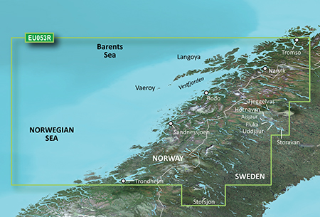
 BlueChart g2 Vision - VEU053R - Trondheim-Tromsø 2015.5 (17.00)
BlueChart g2 Vision - VEU053R - Trondheim-Tromsø 2015.5 (17.00)
See your vessels precise, on-chart position in relation to navaids, coastal features and restricted areas with premium features found in this detailed marine mapping data. Includes all of the features of our BlueChart® g2 product, plus 3-D perspective above and below the waterline, Auto Guidance, high-resolution imagery, and aerial photos of ports, harbors, marinas and landmarks.
- Shaded depth contours, coastlines, spot soundings, navaids, port plans, wrecks, obstructions, intertidal zones, restricted areas and IALA symbols.
- Seamless transitions between zoom levels and more continuity across chart boundaries.
- High resolution satellite imagery for a realistic view of the land and water.
- Aerial photos of ports, harbors, marinas, waterways, navigational landmarks and other POIs.
- Auto Guidance technology searches chart data to suggest the best passage to a destination.
- MarinerEye view 3-D perspective for a quick, easy position fix.
- FishEye view 3-D perspective for an underwater view of the sea floor.
- Safety Shading* enables contour shading for all depth contours shallower than your defined safe depths.
- Fishing Charts* to scope out bottom contours and depth soundings with less visual clutter on the display.
- Plan and organize routes from your computer with HomePort (sold separately).
Coverage
Detailed coverage of the Norway coast from Trondheim to Tromsø. Includes detailed coverage for Sandnessjoen, Bodo, Vaeroy, Langoya, Narvik, and Vestfjorden, as well as lakes Tjeggelvas, Hornavan, Uddjaur, Aisjaur, Fluka, Storavan, Revsundssjön and Storsjön.
FID: FID 3849, PID: 1, RID: 2, VID: 56
Locked Image:
UnLocked Image:
 PiEtU Reviewed by PiEtU on . BlueChart g2 Vision - VEU053R - Trondheim-Tromsø 2015.5 (17.00) BlueChart g2 Vision - VEU053R - Trondheim-Tromsø 2015.5 (17.00) See your vessels precise, on-chart position in relation to navaids, coastal features and restricted areas with premium features found in this detailed marine mapping data. Includes all of the features of our BlueChart® g2 product, plus 3-D perspective above and below the waterline, Auto Guidance, high-resolution imagery, and aerial photos of ports, harbors, marinas and landmarks. Shaded depth contours, coastlines, spot Rating: 5
-
25th March 2021, 06:38 PM #2

Re-uploaded this release
Enjoy.
-
The Following 1 Users Say Thank You to dennisolof For This Useful Post:
- [ Click To Expand ]
-
ta1234 (18th June 2021)


 Register To Reply
Advertisements

Suggested Articles:


 Staff Online
Brazil HERE 2023.Q4
off line filee ..plss