


Results 1 to 3 of 3
-
24th October 2014, 04:52 PM #1
 Garmin Expert
Supporter

 BlueChart g2 - HRU002R - Black Sea & Azov Sea 2015.5 (17.00)
BlueChart g2 - HRU002R - Black Sea & Azov Sea 2015.5 (17.00)
See your vessels precise, on-chart position in relation to navaids, coastal features, anchorages, obstructions, waterways, restricted areas and more with this detailed marine mapping data.
- Shaded depth contours, coastlines, spot soundings, navaids, port plans, wrecks, obstructions, intertidal zones, restricted areas and IALA symbols.
- Seamless transitions between zoom levels and more continuity across chart boundaries.
- Standard 2-D direct overhead or 3-D over the bow map perspective for easy chart reading and orientation.
- Safety Shading* enables contour shading for all depth contours shallower than your defined safe depths.
- Fishing Charts* to scope out bottom contours and depth soundings with less visual clutter on the display.
- Plan and organize routes from your computer with HomePort (sold separately).
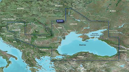
Coverage
Coverage of the Dardanelles, the Sea of Mamara, the Bosporus, the Black Sea, the Dnieper River as far as Kherson, the Bug River as far as Nikolayev and the Sea of Azov.
Detailed coverage includes Burgas and Varna, Bulgaria; Constanta, Romania; Odessa, Nikolayev, Kherson, Sevastopol', Kerch' and Mariupol, Ukraine; Taganrog, Yeysk, Temryuk, Novorossiysk, Poti and Batumi, Russia; Hopa, Giresun, Samsun, Zonguldak, Eregli, Istanbul, Bandirma and Canakkale, Turkey.
FID: 3840, PID: 1, RID: 17, VID: 3
Locked Image:
UnLocked Image:
 PiEtU Reviewed by PiEtU on . BlueChart g2 - HRU002R - Black Sea & Azov Sea 2015.5 (17.00) BlueChart g2 - HRU002R - Black Sea & Azov Sea 2015.5 (17.00) See your vessels precise, on-chart position in relation to navaids, coastal features, anchorages, obstructions, waterways, restricted areas and more with this detailed marine mapping data. Shaded depth contours, coastlines, spot soundings, navaids, port plans, wrecks, obstructions, intertidal zones, restricted areas and IALA symbols. Seamless transitions between zoom levels and more continuity across chart boundaries. Rating: 5
-
The Following 1 Users Say Thank You to PiEtU For This Useful Post:
- [ Click To Expand ]
-
Yurafast (3rd July 2022)
-
25th March 2021, 06:40 PM #2

Re-uploaded this release
Enjoy.
-
The Following 1 Users Say Thank You to dennisolof For This Useful Post:
- [ Click To Expand ]
-
Yurafast (3rd July 2022)
-
4th July 2022, 12:08 AM #3
renew link please


 Register To Reply
Advertisements

Suggested Articles:


 Staff Online
Garmin Cyclops Safety Cameras -...
Garmin Cyclops Jul-26 AustraliaNewZealand...