


![BlueChart g2 Vision - VUS021R - California-Mexico 2014.0 [15.50]](https://www.hostdel.com/banners/Hosting/728x90.gif)
Results 1 to 5 of 5
-
11th October 2014, 04:00 PM #1
 Garmin Expert
Supporter

 BlueChart g2 Vision - VUS021R - California-Mexico 2014.0 [15.50]
BlueChart g2 Vision - VUS021R - California-Mexico 2014.0 (15.50)
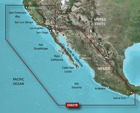
See your vessels precise, on-chart position in relation to navaids, coastal features and restricted areas with premium features found in this detailed marine mapping data. Includes all of the features of our BlueChart® g2 product, plus 3-D perspective above and below the waterline, Auto Guidance, high-resolution imagery, and aerial photos of ports, harbors, marinas and landmarks.
- Shaded depth contours, coastlines, spot soundings, navaids, port plans, wrecks, obstructions, intertidal zones, restricted areas and IALA symbols.
- Seamless transitions between zoom levels and more continuity across chart boundaries.
- High resolution satellite imagery for a realistic view of the land and water.
- Aerial photos of ports, harbors, marinas, waterways, navigational landmarks and other POIs.
- Auto Guidance technology searches chart data to suggest the best passage to a destination.
- MarinerEye view 3-D perspective for a quick, easy position fix.
- FishEye view 3-D perspective for an underwater view of the sea floor.
- Safety Shading* enables contour shading for all depth contours shallower than your defined safe depths.
- Fishing Charts* to scope out bottom contours and depth soundings with less visual clutter on the display.
- Plan and organize routes from your computer with HomePort (sold separately).
Coverage
Point Arena to Puerto Vallarta, including Mendocino, San Francisco Bay, Channel Islands, San Diego, and the Baja Peninsula. General coverage for the Mexican coast, including Mazatlan, Acapulco and Salina Cruz.
FID: 3244, PID: 1, RID: 1, VID: 32
Locked Image:
UnLocked Image:
 PiEtU Reviewed by PiEtU on . BlueChart g2 Vision - VUS021R - California-Mexico 2014.0 [15.50] BlueChart g2 Vision - VUS021R - California-Mexico 2014.0 (15.50) See your vessels precise, on-chart position in relation to navaids, coastal features and restricted areas with premium features found in this detailed marine mapping data. Includes all of the features of our BlueChart® g2 product, plus 3-D perspective above and below the waterline, Auto Guidance, high-resolution imagery, and aerial photos of ports, harbors, marinas and landmarks. Shaded depth contours, coastlines, spot Rating: 5
-
The Following 1 Users Say Thank You to PiEtU For This Useful Post:
- [ Click To Expand ]
-
gvaron (27th October 2020)
-
27th October 2020, 04:22 AM #2
lick broken please upload thanks so much
-
27th October 2020, 05:11 AM #3
Administrator

![BlueChart g2 Vision - VUS021R - California-Mexico 2014.0 [15.50]](http://www.gpsurl.com/images/ranks/administrator.png)
-
23rd February 2021, 09:48 PM #4

Re-uploaded this release
Enjoy.Last edited by dennisolof; 22nd March 2021 at 05:30 PM.
-
The Following 1 Users Say Thank You to dennisolof For This Useful Post:
- [ Click To Expand ]
-
biggerdave (23rd February 2021)
-
20th January 2023, 10:11 AM #5
Link is dead again - bumping in case OP still has the file.
Taking a sailing trip soon and could really use this - thanks in advance!
![BlueChart g2 Vision - VUS021R - California-Mexico 2014.0 [15.50]](https://www.hostdel.com/banners/RDP/300X250.gif)

 Register To Reply
Advertisements
![BlueChart g2 Vision - VUS021R - California-Mexico 2014.0 [15.50]](https://www.hostdel.com/banners/Dedicated/728x90.gif)
 S i m p l e s
 Suggested Articles:
![BlueChart g2 Vision - VUS021R - California-Mexico 2014.0 [15.50]](https://www.hostdel.com/banners/GameServer/728x90.gif)

![BlueChart g2 Vision - VUS021R - California-Mexico 2014.0 [15.50]](https://www.hostdel.com/banners/Email/300X250.gif)


 Staff Online
![BlueChart g2 Vision - VUS021R - California-Mexico 2014.0 [15.50]](https://www.hostdel.com/banners/Dedicated/300x600.gif)
iGO HERE 2022.Q2 Midle East
in post 5 password: nyky