


![BlueChart g2 Vision - VUS510L - St. John - Cape Cod 2014.0 [15.50]](https://www.hostdel.com/banners/Hosting/728x90.gif)
Results 1 to 4 of 4
Threaded View


-
30th April 2014, 10:37 PM #1
 Garmin Expert
Supporter

 BlueChart g2 Vision - VUS510L - St. John - Cape Cod 2014.0 [15.50]
BlueChart g2 Vision - VUS510L - St. John - Cape Cod 2014.0 (15.50)
Part Number: MicroSD/SD (010-C0739-00), Download (010-D0498-00)
See your vessel’s precise, on-chart position in relation to navaids, coastal features and restricted areas with premium features found in this detailed marine mapping data. Includes all of the features of our BlueChart® g2 product, plus 3-D perspective above and below the waterline, Auto Guidance, high-resolution imagery, and aerial photos of ports, harbors, marinas and landmarks.
- Shaded depth contours, coastlines, spot soundings, navaids, port plans, wrecks, obstructions, intertidal zones, restricted areas and IALA symbols.
- Seamless transitions between zoom levels and more continuity across chart boundaries.
- High resolution satellite imagery for a realistic view of the land and water.
- Aerial photos of ports, harbors, marinas, waterways, navigational landmarks and other POIs.
- Auto Guidance technology searches chart data to suggest the best passage to a destination.
- MarinerEye view 3-D perspective for a quick, easy position fix.
- FishEye view 3-D perspective for an underwater view of the sea floor.
- Safety Shading* enables contour shading for all depth contours shallower than your defined safe depths.
- Fishing Charts* to scope out bottom contours and depth soundings with less visual clutter on the display.
- Plan and organize routes from your computer with HomePort™ (sold separately).
Coverage
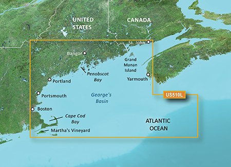
Detailed coverage the east coast of the U.S. and Canada from Cape Cod to St. John, NB, including Boston, MA, Portsmouth, NH, and Portland, ME, as well as the Kennebec R. to Augusta, ME and the Penobscot R. to Bangor, ME. Coverage also includes Martha's Vineyard, Nantucket Island, Grand Manan Island, Mt. Desert Island, and Calais, ME as well as St. Mary's Bay and Yarmouth, NS. Bathymetric coverage includes George's Basin, Franklin Basin, and the Northeast Channel.
FID: 3245, PID: 1, RID: 4, VID: 27
Locked Image:
UnLocked Image:
 PiEtU Reviewed by PiEtU on . BlueChart g2 Vision - VUS510L - St. John - Cape Cod 2014.0 [15.50] BlueChart g2 Vision - VUS510L - St. John - Cape Cod 2014.0 (15.50) Part Number: MicroSD/SD (010-C0739-00), Download (010-D0498-00) See your vessel’s precise, on-chart position in relation to navaids, coastal features and restricted areas with premium features found in this detailed marine mapping data. Includes all of the features of our BlueChart® g2 product, plus 3-D perspective above and below the waterline, Auto Guidance, high-resolution imagery, and aerial photos of ports, harbors, Rating: 5
![BlueChart g2 Vision - VUS510L - St. John - Cape Cod 2014.0 [15.50]](https://www.hostdel.com/banners/RDP/300X250.gif)

 Register To Reply
Advertisements
![BlueChart g2 Vision - VUS510L - St. John - Cape Cod 2014.0 [15.50]](https://www.hostdel.com/banners/Dedicated/728x90.gif)
Suggested Articles:
![BlueChart g2 Vision - VUS510L - St. John - Cape Cod 2014.0 [15.50]](https://www.hostdel.com/banners/GameServer/728x90.gif)
Similar Threads
-
BlueChart g2 Vision - VRU002R-Black Sea & Azov Sea 2014.0 [15.50]
By p33dro in forum Garmin ArchivesReplies: 6Last Post: 31st October 2022, 02:54 PM -
BlueChart g2 Vision - VEU706L - UK-Ireland-The Netherlands 2014.0 [15.50]
By p33dro in forum Garmin MapsReplies: 12Last Post: 28th August 2021, 06:01 PM -
BlueChart g2 Vision - VEU717L - East Mediterranean & Black Sea 2014.0 [15.50]
By p33dro in forum Garmin MapsReplies: 4Last Post: 28th March 2021, 05:31 AM -
BlueChart g2 Vision - VEU714L - Iberian Pen.-Azores-Canaries 2014.0 [15.50]
By p33dro in forum Garmin ArchivesReplies: 4Last Post: 4th August 2020, 09:34 PM -
BlueChart g2 Vision - VUS510L - St. John - Cape Cod 2014.0 [15.50]
By PiEtU in forum Garmin MapsReplies: 0Last Post: 30th April 2014, 10:37 PM

![BlueChart g2 Vision - VUS510L - St. John - Cape Cod 2014.0 [15.50]](https://www.hostdel.com/banners/Email/300X250.gif)


 Staff Online
![BlueChart g2 Vision - VUS510L - St. John - Cape Cod 2014.0 [15.50]](https://www.hostdel.com/banners/Dedicated/300x600.gif)
JetMouse Garmin Keygen v1.5 with...
Link updated to hosting service