


![BlueChart g2 - HEU714L - Iberian Pen.-Azores-Canaries 2014.0 [15.50]](https://www.hostdel.com/banners/Hosting/728x90.gif)
Results 1 to 4 of 4
-
23rd March 2014, 12:36 PM #1
 Garmin Master

 BlueChart g2 - HEU714L - Iberian Pen.-Azores-Canaries 2014.0 [15.50]
BlueChart g2 - HEU714L - Iberian Pen.-Azores-Canaries 2014.0 (15.50)
Part Number: Download (010-D0592-00)
See your vessels precise, on-chart position in relation to navaids, coastal features, anchorages, obstructions, waterways, restricted areas and more with this detailed marine mapping data.
- Shaded depth contours, coastlines, spot soundings, navaids, port plans, wrecks, obstructions, intertidal zones, restricted areas and IALA symbols.
- Seamless transitions between zoom levels and more continuity across chart boundaries.
- Standard 2-D direct overhead or 3-D over the bow map perspective for easy chart reading and orientation.
- Safety Shading* enables contour shading for all depth contours shallower than your defined safe depths.
- Fishing Charts* to scope out bottom contours and depth soundings with less visual clutter on the display.
- Plan and organize routes from your computer with HomePort (sold separately).
Coverage
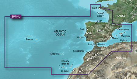
Detailed coverage of the entire Iberian Peninsula including the Bay of Biscay from Brest, Fr. to Gijón, Spain, as well as all of the Portuguese coast including Porto and Lisboa, Pt., and Sevilla, Sp. Mediterrenean coverage from the Strait of Gibraltar to Perpignan, Fr., including Málaga, Alicante, Valencia, and Barcelona, Sp., as well as the Iles of Mallorca and Menorca. Detailed coverage also includes the Azores, Madeira and Canary Islands, as well as coverage of the coast of North Africa from Jijel, Alg. to El Aaiun in Western Sahara, including Algiers, Alg. and Casablanca, Mor.
FID: 3257, PID: 1, RID: 4, VID: 20
Locked Image:
UnLocked Image:
 p33dro Reviewed by p33dro on . BlueChart g2 - HEU714L - Iberian Pen.-Azores-Canaries 2014.0 [15.50] BlueChart g2 - HEU714L - Iberian Pen.-Azores-Canaries 2014.0 (15.50) Part Number: Download (010-D0592-00) See your vessels precise, on-chart position in relation to navaids, coastal features, anchorages, obstructions, waterways, restricted areas and more with this detailed marine mapping data. Shaded depth contours, coastlines, spot soundings, navaids, port plans, wrecks, obstructions, intertidal zones, restricted areas and IALA symbols. Seamless transitions between zoom levels Rating: 5When nothing goes right, go left.
-
The Following 2 Users Say Thank You to p33dro For This Useful Post:
- [ Click To Expand ]
-
-
26th March 2021, 06:41 PM #2

Re-uploaded this release
Enjoy.
-
24th November 2023, 06:11 AM #3
-
10th March 2024, 06:16 AM #4
Re-uploaded this release please
![BlueChart g2 - HEU714L - Iberian Pen.-Azores-Canaries 2014.0 [15.50]](https://www.hostdel.com/banners/RDP/300X250.gif)

 Register To Reply
Advertisements
![BlueChart g2 - HEU714L - Iberian Pen.-Azores-Canaries 2014.0 [15.50]](https://www.hostdel.com/banners/Dedicated/728x90.gif)
Suggested Articles:
![BlueChart g2 - HEU714L - Iberian Pen.-Azores-Canaries 2014.0 [15.50]](https://www.hostdel.com/banners/GameServer/728x90.gif)
Similar Threads
-
BlueChart g2 Vision - VUS009R - Jacksonville-Key West 2014 [15.50]
By PiEtU in forum Garmin MapsReplies: 4Last Post: 12th April 2023, 11:08 PM -
BlueChart g2 Vision - VEU714L - Iberian Pen.-Azores-Canaries 2014.0 [15.50]
By p33dro in forum Garmin ArchivesReplies: 4Last Post: 4th August 2020, 09:34 PM -
BlueChart g2 Vision - VEU714L - Iberian Pen.-Azores-Canaries 2014.0 [15.50]
By p33dro in forum Garmin MapsReplies: 1Last Post: 26th May 2017, 12:19 AM -
BlueChart g2 - HEU714L - Iberian Pen.-Azores-Canaries 2014.0 [15.50]
By p33dro in forum Garmin MapsReplies: 0Last Post: 23rd March 2014, 12:36 PM -
BlueChart g2 - HEU706L - UK-Ireland-The Netherlands 2014.0 [15.50]
By p33dro in forum Garmin ArchivesReplies: 0Last Post: 22nd March 2014, 10:32 PM

![BlueChart g2 - HEU714L - Iberian Pen.-Azores-Canaries 2014.0 [15.50]](https://www.hostdel.com/banners/Email/300X250.gif)


 Staff Online
![BlueChart g2 - HEU714L - Iberian Pen.-Azores-Canaries 2014.0 [15.50]](https://www.hostdel.com/banners/Dedicated/300x600.gif)
Garmin Cyclops Safety Cameras -...
Garmin Cyclops Jul-26 AustraliaNewZealand...