


Results 1 to 7 of 7
Threaded View


-
6th April 2016, 09:02 PM #1
 Garmin Expert
Supporter

 TOPO Southern Africa v3 PRO
TOPO Southern Africa v3 PRO
We've mapped every hill and valley for your next great adventure in Southern Africa. These highly detailed topographic maps cover the finer destinations for recreational outdoor activities and serve as your ultimate guide to navigating trails, roads, rivers and forests.
- Includes ActiveRouting¹, allowing you to customize and specifically plan routes for the entire road and trail network. The activity-specific routing can be used in BaseCamp™ and on your compatible device.
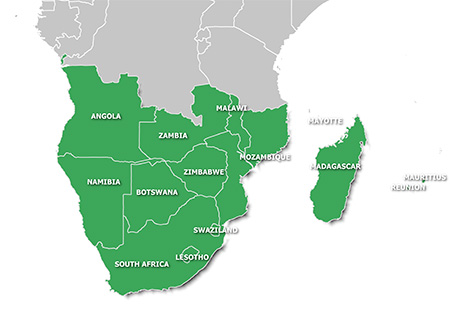
- Shows seamless coverage between 14 different countries in Southern Africa. For the countries of Namibia and South Africa, it includes farm boundary information, which can help identify property borders
- Displays searchable business/touristic points of interests, including searchable geographic places and mountain ranges
- Includes an improved basemap with faster panning so you can see height contour lines and Digital Elevation Model (DEM) to easily estimate terrain difficulty
Features topographic coverage for Angola, Botswana, Lesotho, Madagascar, Malawi, Mauritius, Mayotte, Mozambique, Namibia, Reunion, South Africa, Swaziland, Zambia and Zimbabwe.
FID: ZA 3976
FID: Madagascar 4090
Image: Southern Africa v3 PRO & Madagascar
PiEtU Reviewed by PiEtU on . TOPO Southern Africa v3 PRO TOPO Southern Africa v3 PRO We've mapped every hill and valley for your next great adventure in Southern Africa. These highly detailed topographic maps cover the finer destinations for recreational outdoor activities and serve as your ultimate guide to navigating trails, roads, rivers and forests. Includes ActiveRouting¹, allowing you to customize and specifically plan routes for the entire road and trail network. The activity-specific routing can be used in BaseCamp™ and on your Rating: 5
-
The Following 4 Users Say Thank You to PiEtU For This Useful Post:
- [ Click To Expand ]
-


 Register To Reply
Advertisements

Suggested Articles:


 Staff Online
First time update Motorrad V
Can the PC see the device in Explorer USB...