


![BlueChart g2 - HCA015R - Canada g2 v2015.0 [16.50]](https://www.hostdel.com/banners/Hosting/728x90.gif)
Results 1 to 10 of 25
Threaded View


-
22nd June 2015, 11:35 AM #1
 Garmin Expert
Supporter

 BlueChart g2 - HCA015R - Canada g2 v2015.0 [16.50]
BlueChart g2 - HCA015R - Canada g2 v2015.0 (16.50)
See your vessels precise, on-chart position in relation to navaids, coastal features, anchorages, obstructions, waterways, restricted areas and more with this detailed marine mapping data.
- Shaded depth contours, coastlines, spot soundings, navaids, port plans, wrecks, obstructions, intertidal zones, restricted areas and IALA symbols.
- Seamless transitions between zoom levels and more continuity across chart boundaries.
- Standard 2-D direct overhead or 3-D over the bow map perspective for easy chart reading and orientation.
- Safety Shading* enables contour shading for all depth contours shallower than your defined safe depths.
- Fishing Charts* to scope out bottom contours and depth soundings with less visual clutter on the display.
- Plan and organize routes from your computer with HomePort (sold separately).
Coverage
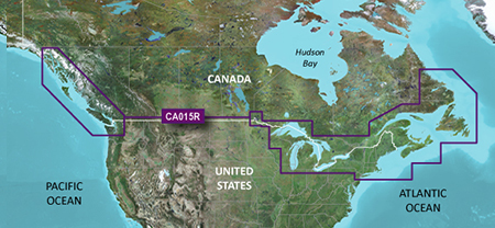
Provides detailed coastal coverage of the North America east Coast from Nain, NL to Raritan Bay, NY featuring Newfoundland, Île d'Anticosti, New York Harbor, and full U.S. and Canadian coverage of the Great Lakes in their entirety. The North American west Coast is covered from Glacier Bay, AK to Aberdeen, WA featuring British Columbia, Vancouver, the Queen Charlotte Islands, and Puget Sound.
FID 3643, PID 1, region 19,4
Locked Image:
UnLocked Image:
 PiEtU Reviewed by PiEtU on . BlueChart g2 - HCA015R - Canada g2 v2015.0 [16.50] BlueChart g2 - HCA015R - Canada g2 v2015.0 (16.50) See your vessels precise, on-chart position in relation to navaids, coastal features, anchorages, obstructions, waterways, restricted areas and more with this detailed marine mapping data. Shaded depth contours, coastlines, spot soundings, navaids, port plans, wrecks, obstructions, intertidal zones, restricted areas and IALA symbols. Seamless transitions between zoom levels and more continuity across chart boundaries. Rating: 5
-
The Following 2 Users Say Thank You to PiEtU For This Useful Post:
- [ Click To Expand ]
-
protecteur (18th December 2017), Vitinesgonzalez (28th July 2015)
![BlueChart g2 - HCA015R - Canada g2 v2015.0 [16.50]](https://www.hostdel.com/banners/RDP/300X250.gif)

 Register To Reply
Advertisements
![BlueChart g2 - HCA015R - Canada g2 v2015.0 [16.50]](https://www.hostdel.com/banners/Dedicated/728x90.gif)
Suggested Articles:
![BlueChart g2 - HCA015R - Canada g2 v2015.0 [16.50]](https://www.hostdel.com/banners/GameServer/728x90.gif)

![BlueChart g2 - HCA015R - Canada g2 v2015.0 [16.50]](https://www.hostdel.com/banners/Email/300X250.gif)


 Staff Online
![BlueChart g2 - HCA015R - Canada g2 v2015.0 [16.50]](https://www.hostdel.com/banners/Dedicated/300x600.gif)
South_America_LATAM_HERE_2021-Q2
Gracias por los mapas