


![BlueChart g2 - HEU015R - Aegean Sea & Sea of Marmara 2015.0 [16.50]](https://www.hostdel.com/banners/Hosting/728x90.gif)
Results 11 to 15 of 15
Threaded View


-
14th May 2015, 11:55 PM #1
 Garmin Expert
Supporter

 BlueChart g2 - HEU015R - Aegean Sea & Sea of Marmara 2015.0 [16.50]
BlueChart g2 - HEU015R - Aegean Sea & Sea of Marmara 2015.0 (16.50)
See your vessels precise, on-chart position in relation to navaids, coastal features, anchorages, obstructions, waterways, restricted areas and more with this detailed marine mapping data.
- Shaded depth contours, coastlines, spot soundings, navaids, port plans, wrecks, obstructions, intertidal zones, restricted areas and IALA symbols.
- Seamless transitions between zoom levels and more continuity across chart boundaries.
- Standard 2-D direct overhead or 3-D over the bow map perspective for easy chart reading and orientation.
- Safety Shading* enables contour shading for all depth contours shallower than your defined safe depths.
- Fishing Charts* to scope out bottom contours and depth soundings with less visual clutter on the display.
- Plan and organize routes from your computer with HomePort (sold separately).
Coverage
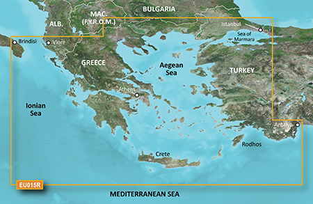
Including all of the Greek coast and Aegean Sea; Turkey from Istanbul and Sea of Marmara to Antalya; and Brindisi, Italy.
FID 3647, PID 1, region 2,21
Locked Image:
UnLocked Image:
 PiEtU Reviewed by PiEtU on . BlueChart g2 - HEU015R - Aegean Sea & Sea of Marmara 2015.0 [16.50] BlueChart g2 - HEU015R - Aegean Sea & Sea of Marmara 2015.0 (16.50) See your vessels precise, on-chart position in relation to navaids, coastal features, anchorages, obstructions, waterways, restricted areas and more with this detailed marine mapping data. Shaded depth contours, coastlines, spot soundings, navaids, port plans, wrecks, obstructions, intertidal zones, restricted areas and IALA symbols. Seamless transitions between zoom levels and more continuity across chart Rating: 5
-
The Following 7 Users Say Thank You to PiEtU For This Useful Post:
- [ Click To Expand ]
-

 Register To Reply
Advertisements
![BlueChart g2 - HEU015R - Aegean Sea & Sea of Marmara 2015.0 [16.50]](https://www.hostdel.com/banners/Dedicated/728x90.gif)
Suggested Articles:
![BlueChart g2 - HEU015R - Aegean Sea & Sea of Marmara 2015.0 [16.50]](https://www.hostdel.com/banners/GameServer/728x90.gif)

![BlueChart g2 - HEU015R - Aegean Sea & Sea of Marmara 2015.0 [16.50]](https://www.hostdel.com/banners/Email/300X250.gif)


 Staff Online
![BlueChart g2 - HEU015R - Aegean Sea & Sea of Marmara 2015.0 [16.50]](https://www.hostdel.com/banners/Dedicated/300x600.gif)
City Navigator North America NT...
Try using your device name in search at the top...