


![BlueChart g2 Vision - VEU710L - Skagerrak-Denmark-Germany 2014.0 [15.50]](https://www.hostdel.com/banners/Hosting/728x90.gif)
Results 1 to 9 of 9
Threaded View


-
20th June 2014, 03:40 AM #1
 Garmin Expert
Supporter

 BlueChart g2 Vision - VEU710L - Skagerrak-Denmark-Germany 2014.0 [15.50]
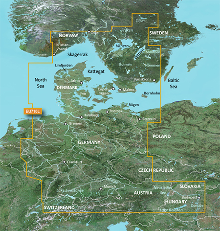
BlueChart g2 Vision - VEU710L - Skagerrak-Denmark-Germany 2014.0 (15.50)
See your vessel’s precise, on-chart position in relation to navaids, coastal features and restricted areas with premium features found in this detailed marine mapping data. Includes all of the features of our BlueChart® g2 product, plus 3-D perspective above and below the waterline, Auto Guidance, high-resolution imagery, and aerial photos of ports, harbors, marinas and landmarks.
- Shaded depth contours, coastlines, spot soundings, navaids, port plans, wrecks, obstructions, intertidal zones, restricted areas and IALA symbols.
- Seamless transitions between zoom levels and more continuity across chart boundaries.
- High resolution satellite imagery for a realistic view of the land and water.
- Aerial photos of ports, harbors, marinas, waterways, navigational landmarks and other POIs.
- Auto Guidance technology searches chart data to suggest the best passage to a destination.
- MarinerEye view 3-D perspective for a quick, easy position fix.
- FishEye view 3-D perspective for an underwater view of the sea floor.
- Safety Shading* enables contour shading for all depth contours shallower than your defined safe depths.
- Fishing Charts* to scope out bottom contours and depth soundings with less visual clutter on the display.
- Plan and organize routes from your computer with HomePort™ (sold separately).
Coverage
Detailed coverage of the coasts of Denmark, Germany, and southern Norway and Sweden from Kristiansand, NO to Karlskrona, SE including Oslo, NO along with Malmö and Trelleborg, SE, the Telemark Canal and Lakes Vänern, Vättern, Mjörn, Sommen, Nommen, Siljan and Bolmen, the Skagerrak and the Kattegat. Coverage also includes all major inland canals and rivers of Germany including the Mittelland Canal, the Rhine River, the Main River to Bamberg, the Danube River from Kelheim to Passau, the Saar River, the Moselle River to Metz, FR and the Ems River to Papenburg, the Weser River to Minden, the Elbe River to Dresden, Lake Constance, Lake Balaton and the Neusiedler See.
FID: 3248, PID: 1, RID: 4, VID: 16
Locked Image:
UnLocked Image:
 PiEtU Reviewed by PiEtU on . BlueChart g2 Vision - VEU710L - Skagerrak-Denmark-Germany 2014.0 [15.50] BlueChart g2 Vision - VEU710L - Skagerrak-Denmark-Germany 2014.0 (15.50) See your vessel’s precise, on-chart position in relation to navaids, coastal features and restricted areas with premium features found in this detailed marine mapping data. Includes all of the features of our BlueChart® g2 product, plus 3-D perspective above and below the waterline, Auto Guidance, high-resolution imagery, and aerial photos of ports, harbors, marinas and landmarks. Shaded depth contours, Rating: 5
![BlueChart g2 Vision - VEU710L - Skagerrak-Denmark-Germany 2014.0 [15.50]](https://www.hostdel.com/banners/RDP/300X250.gif)

 Register To Reply
Advertisements
![BlueChart g2 Vision - VEU710L - Skagerrak-Denmark-Germany 2014.0 [15.50]](https://www.hostdel.com/banners/Dedicated/728x90.gif)
Suggested Articles:
![BlueChart g2 Vision - VEU710L - Skagerrak-Denmark-Germany 2014.0 [15.50]](https://www.hostdel.com/banners/GameServer/728x90.gif)

![BlueChart g2 Vision - VEU710L - Skagerrak-Denmark-Germany 2014.0 [15.50]](https://www.hostdel.com/banners/Email/300X250.gif)


 Staff Online
![BlueChart g2 Vision - VEU710L - Skagerrak-Denmark-Germany 2014.0 [15.50]](https://www.hostdel.com/banners/Dedicated/300x600.gif)
City Navigator China NT 2019.40
Hi Paul, thank you for the share, unfortunately...