


Results 1 to 10 of 11
Threaded View


-
23rd March 2014, 02:49 AM #1
 Garmin Master

 BlueChart g2 Vision - VEU715L - Mediterranean West 2014.0 (15.50)
BlueChart g2 Vision - VEU715L - Mediterranean West 2014.0 (15.50)
Part Number: MicroSD/SD (010-C0862-00), Download (010-D0510-00)
See your vessels precise, on-chart position in relation to navaids, coastal features and restricted areas with premium features found in this detailed marine mapping data. Includes all of the features of our BlueChart® g2 product, plus 3-D perspective above and below the waterline, Auto Guidance, high-resolution imagery, and aerial photos of ports, harbors, marinas and landmarks.
- Shaded depth contours, coastlines, spot soundings, navaids, port plans, wrecks, obstructions, intertidal zones, restricted areas and IALA symbols.
- Seamless transitions between zoom levels and more continuity across chart boundaries.
- High resolution satellite imagery for a realistic view of the land and water.
- Aerial photos of ports, harbors, marinas, waterways, navigational landmarks and other POIs.
- Auto Guidance technology searches chart data to suggest the best passage to a destination.
- MarinerEye view 3-D perspective for a quick, easy position fix.
- FishEye view 3-D perspective for an underwater view of the sea floor.
- Safety Shading* enables contour shading for all depth contours shallower than your defined safe depths.
- Fishing Charts* to scope out bottom contours and depth soundings with less visual clutter on the display.
- Plan and organize routes from your computer with HomePort (sold separately).
Coverage
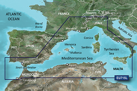
Detailed coverage of the western Mediterranean Sea from Sines, Portugal through the Strait of Gibraltar to the west coast of Italy, including Cádiz and Barcelona, Sp., Marseille and Nice, Fr., Rome, and Naples, It. Also includes detailed coverage of the Isles of Mallorca and Menorca, Corsica and Sardinia, Sicily, and Malta, as well as Lago Maggiore, Lago D' Iseo, and Lago di Garda in Northern Italy. North African coverage from Tunis, Tun. to Casablanca, Mor. including Algiers, Alg.
FID: 3248, PID: 1, RID: 4, VID: 21
Locked Image:
UnLocked Image:
 p33dro Reviewed by p33dro on . BlueChart g2 Vision - VEU715L - Mediterranean West 2014.0 (15.50) BlueChart g2 Vision - VEU715L - Mediterranean West 2014.0 (15.50) Part Number: MicroSD/SD (010-C0862-00), Download (010-D0510-00) See your vessels precise, on-chart position in relation to navaids, coastal features and restricted areas with premium features found in this detailed marine mapping data. Includes all of the features of our BlueChart® g2 product, plus 3-D perspective above and below the waterline, Auto Guidance, high-resolution imagery, and aerial photos of ports, harbors, Rating: 5When nothing goes right, go left.


 Register To Reply
Advertisements

Suggested Articles:

Similar Threads
-
BlueChart g2 Vision - VEU058R - Greenland West 2014.0 [15.50]
By PiEtU in forum Garmin ArchivesReplies: 1Last Post: 25th March 2021, 10:03 PM -
BlueChart g2 Vision - VEU716L - Mediterranean Central 2014.0 [15.50]
By p33dro in forum Garmin ArchivesReplies: 3Last Post: 12th October 2019, 02:14 AM -
BlueChart g2 Vision - VEU016R - Mediterranean Southeast 2014.5 [16.00]
By PiEtU in forum Garmin MapsReplies: 2Last Post: 5th July 2019, 10:27 PM -
BlueChart g2 Vision - VEU058R - Greenland West 2014.0 [15.50]
By PiEtU in forum Garmin MapsReplies: 0Last Post: 26th April 2014, 12:45 AM -
BlueChart g2 Vision - VEU716L - Mediterranean Central 2014.0 [15.50]
By p33dro in forum Garmin MapsReplies: 0Last Post: 23rd March 2014, 12:28 PM


 Staff Online
2023.Q2 Here Australia,New Zealand
Australia New_Zealand HERE 2024.Q2 please