


Results 1 to 1 of 1
-
6th April 2016, 08:56 PM #1
 Garmin Expert
Supporter

 TOPO Explorer Svalbard
TOPO Explorer Svalbard
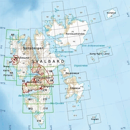
Explore the Svalbard islands with these detailed topographic maps, including glaciers, moraines, coastlines and lakes. You'll also have coverage of national park borders, conservation areas and nature reserves.
- Provides 1:100,000 scale aerial photography and overview maps based on 1:1 million map data from the Norwegian Polar Institute
- Contains an extensive points of interest database with road and trail data
- Displays topographic features, including land use, glaciers, moraines and built up areas, and hydrographic features, including coastlines, lakes and rivers
- Shows national park borders, conservation areas and nature reserves
- Displays digital elevation model (DEM)
- Includes MapSource® software which allows you to plan and organize trips by transferring waypoints, routes and tracks between your computer and device
Features digital topographic maps for common and allowed travel areas in Svalbard.
FID: 1491
Original Image:
PiEtU Reviewed by PiEtU on . TOPO Explorer Svalbard TOPO Explorer Svalbard Explore the Svalbard islands with these detailed topographic maps, including glaciers, moraines, coastlines and lakes. You'll also have coverage of national park borders, conservation areas and nature reserves. Provides 1:100,000 scale aerial photography and overview maps based on 1:1 million map data from the Norwegian Polar Institute Contains an extensive points of interest database with road and trail data Displays topographic features, including Rating: 5
-
The Following 1 Users Say Thank You to PiEtU For This Useful Post:
- [ Click To Expand ]
-
trapito (27th June 2016)


 Register To Reply
Advertisements

Suggested Articles:


 Staff Online
Codegen-tool in Excel for...
Update in post #1: May 25 2024 11:00 AM: Added...