


![BlueChart g2 - HEU018R - Benelux Offshore & Inland Waters 2015.5 [17.00]](https://www.hostdel.com/banners/Hosting/728x90.gif)
Results 1 to 5 of 5
Threaded View


-
9th March 2016, 03:02 PM #1
 Garmin Expert
Supporter

 BlueChart g2 - HEU018R - Benelux Offshore & Inland Waters 2015.5 [17.00]
BlueChart g2 - HEU018R - Benelux Offshore & Inland Waters 2015.5 (17.00)
See your vessel’s precise, on-chart position in relation to navaids, coastal features, anchorages, obstructions, waterways, restricted areas and more with this detailed marine mapping data.
- Shaded depth contours, coastlines, spot soundings, navaids, port plans, wrecks, obstructions, intertidal zones, restricted areas and IALA symbols.
- Seamless transitions between zoom levels and more continuity across chart boundaries.
- Standard 2-D direct overhead or 3-D “over the bow” map perspective for easy chart reading and orientation.
- Safety Shading* enables contour shading for all depth contours shallower than your defined safe depths.
- Fishing Charts* to scope out bottom contours and depth soundings with less visual clutter on the display.
- Plan and organize routes from your computer with HomePort™ (sold separately).
Coverage
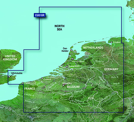
Continental coverage: from Spiekeroog, Germany to Calais, France, including The Netherlands and Belgium coast entirely. Great Britain coverage: from Whitstable to Folkestone.
FID: 3840, PID: 1, RID: 2, VID: 24
Locked Image:
UnLocked Image:
 PiEtU Reviewed by PiEtU on . BlueChart g2 - HEU018R - Benelux Offshore & Inland Waters 2015.5 [17.00] BlueChart g2 - HEU018R - Benelux Offshore & Inland Waters 2015.5 (17.00) See your vessel’s precise, on-chart position in relation to navaids, coastal features, anchorages, obstructions, waterways, restricted areas and more with this detailed marine mapping data. Shaded depth contours, coastlines, spot soundings, navaids, port plans, wrecks, obstructions, intertidal zones, restricted areas and IALA symbols. Seamless transitions between zoom levels and more continuity across chart Rating: 5
-
The Following 1 Users Say Thank You to PiEtU For This Useful Post:
- [ Click To Expand ]
-
pozidriv (29th May 2017)
![BlueChart g2 - HEU018R - Benelux Offshore & Inland Waters 2015.5 [17.00]](https://www.hostdel.com/banners/RDP/300X250.gif)

 Register To Reply
Advertisements
![BlueChart g2 - HEU018R - Benelux Offshore & Inland Waters 2015.5 [17.00]](https://www.hostdel.com/banners/Dedicated/728x90.gif)
Suggested Articles:
![BlueChart g2 - HEU018R - Benelux Offshore & Inland Waters 2015.5 [17.00]](https://www.hostdel.com/banners/GameServer/728x90.gif)

![BlueChart g2 - HEU018R - Benelux Offshore & Inland Waters 2015.5 [17.00]](https://www.hostdel.com/banners/Email/300X250.gif)


 Staff Online
![BlueChart g2 - HEU018R - Benelux Offshore & Inland Waters 2015.5 [17.00]](https://www.hostdel.com/banners/Dedicated/300x600.gif)
City Navigator North America NT...
OLD version look in City Navigator North America...