


![BlueChart g2 Vision - VUS515L - Brownsville-Key Largo v2015.50 [v.17.00]](https://www.hostdel.com/banners/Hosting/728x90.gif)
Results 1 to 7 of 7
Threaded View


-
1st March 2016, 04:29 PM #1
 Garmin Expert
Supporter

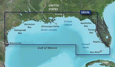
 BlueChart g2 Vision - VUS515L - Brownsville-Key Largo v2015.50 [v.17.00]
BlueChart g2 Vision - VUS515L - Brownsville-Key Largo v2015.50 (v.17.00)
Detailed coverage of the Gulf of Mexico from Brownsville, TX to Plantation Key, FL including Corpus Christi, TX, Matagorda Bay, Galveston Bay, Port Arthur, TX, Atchafalaya Bay, the Mississippi Delta, Chandeleur Islands, Tampa Bay and the Florida Keys west of Key Largo. Also includes Lake Ponchartrain and Lake Maurepas to Vermilion Bay and Lake Calcasieu. Bathymetric coverage of offshore features from Northwest Slope to Tortugas Terrace including Keathley Canyon, Green Canyon, Orca Basin, Mississippi Canyon, Southwest Pass, DeSoto Canyon, Florida Middle Ground, Howell Hook, and Tortugas Bank.
FID 3847, PID 1, region 4,32
Dowmload:
PiEtU Reviewed by PiEtU on . BlueChart g2 Vision - VUS515L - Brownsville-Key Largo v2015.50 [v.17.00] BlueChart g2 Vision - VUS515L - Brownsville-Key Largo v2015.50 (v.17.00) Detailed coverage of the Gulf of Mexico from Brownsville, TX to Plantation Key, FL including Corpus Christi, TX, Matagorda Bay, Galveston Bay, Port Arthur, TX, Atchafalaya Bay, the Mississippi Delta, Chandeleur Islands, Tampa Bay and the Florida Keys west of Key Largo. Also includes Lake Ponchartrain and Lake Maurepas to Vermilion Bay and Lake Calcasieu. Bathymetric coverage of offshore features from Northwest Slope to Rating: 5
![BlueChart g2 Vision - VUS515L - Brownsville-Key Largo v2015.50 [v.17.00]](https://www.hostdel.com/banners/RDP/300X250.gif)

 Register To Reply
Advertisements
![BlueChart g2 Vision - VUS515L - Brownsville-Key Largo v2015.50 [v.17.00]](https://www.hostdel.com/banners/Dedicated/728x90.gif)
Suggested Articles:
![BlueChart g2 Vision - VUS515L - Brownsville-Key Largo v2015.50 [v.17.00]](https://www.hostdel.com/banners/GameServer/728x90.gif)

![BlueChart g2 Vision - VUS515L - Brownsville-Key Largo v2015.50 [v.17.00]](https://www.hostdel.com/banners/Email/300X250.gif)


 Staff Online
![BlueChart g2 Vision - VUS515L - Brownsville-Key Largo v2015.50 [v.17.00]](https://www.hostdel.com/banners/Dedicated/300x600.gif)
JetMouse Garmin Keygen v1.5 with...
I also cant download. i read posts 12 and 15 with...