


![BlueChart g2 Vision - VRU002R-Black Sea & Azov Sea 2014.0 [15.50]](https://www.hostdel.com/banners/Hosting/728x90.gif)
Results 1 to 7 of 7
Threaded View


-
25th March 2014, 05:38 PM #1
 Garmin Master

 BlueChart g2 Vision - VRU002R-Black Sea & Azov Sea 2014.0 [15.50]
BlueChart g2 Vision - VRU002R-Black Sea & Azov Sea 2014.0 (15.50)
Part Number: MicroSD/SD (010-C1064-00), Download (010-D1087-00)
See your vessel’s precise, on-chart position in relation to navaids, coastal features and restricted areas with premium features found in this detailed marine mapping data. Includes all of the features of our BlueChart® g2 product, plus 3-D perspective above and below the waterline, Auto Guidance, high-resolution imagery, and aerial photos of ports, harbors, marinas and landmarks.
- Shaded depth contours, coastlines, spot soundings, navaids, port plans, wrecks, obstructions, intertidal zones, restricted areas and IALA symbols.
- Seamless transitions between zoom levels and more continuity across chart boundaries.
- High resolution satellite imagery for a realistic view of the land and water.
- Aerial photos of ports, harbors, marinas, waterways, navigational landmarks and other POIs.
- Auto Guidance technology searches chart data to suggest the best passage to a destination.
- MarinerEye view 3-D perspective for a quick, easy position fix.
- FishEye view 3-D perspective for an underwater view of the sea floor.
- Safety Shading* enables contour shading for all depth contours shallower than your defined safe depths.
- Fishing Charts* to scope out bottom contours and depth soundings with less visual clutter on the display.
- Plan and organize routes from your computer with HomePort™ (sold separately).
Coverage
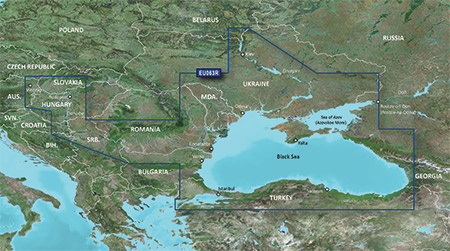
Coverage of the Dardanelles, the Sea of Mamara, the Bosporus, the Black Sea, the Dnieper River as far as Kherson, the Bug River as far as Nikolayev and the Sea of Azov.
Detailed coverage includes Burgas and Varna, Bulgaria; Constanta, Romania; Odessa, Nikolayev, Kherson, Sevastopol', Kerch' and Mariupol, Ukraine; Taganrog, Yeysk, Temryuk, Novorossiysk, Poti and Batumi, Russia; Hopa, Giresun, Samsun, Zonguldak, Eregli, Istanbul, Bandirma and Canakkale, Turkey.
FID: 3247, PID: 1, RID: 17, VID: 3
Locked Image:
UnLocked Image:
 p33dro Reviewed by p33dro on . BlueChart g2 Vision - VRU002R-Black Sea & Azov Sea 2014.0 [15.50] BlueChart g2 Vision - VRU002R-Black Sea & Azov Sea 2014.0 (15.50) Part Number: MicroSD/SD (010-C1064-00), Download (010-D1087-00) See your vessel’s precise, on-chart position in relation to navaids, coastal features and restricted areas with premium features found in this detailed marine mapping data. Includes all of the features of our BlueChart® g2 product, plus 3-D perspective above and below the waterline, Auto Guidance, high-resolution imagery, and aerial photos of ports, harbors, Rating: 5When nothing goes right, go left.
-
The Following 2 Users Say Thank You to p33dro For This Useful Post:
- [ Click To Expand ]
-
![BlueChart g2 Vision - VRU002R-Black Sea & Azov Sea 2014.0 [15.50]](https://www.hostdel.com/banners/RDP/300X250.gif)

 Register To Reply
Advertisements
![BlueChart g2 Vision - VRU002R-Black Sea & Azov Sea 2014.0 [15.50]](https://www.hostdel.com/banners/Dedicated/728x90.gif)
Suggested Articles:
![BlueChart g2 Vision - VRU002R-Black Sea & Azov Sea 2014.0 [15.50]](https://www.hostdel.com/banners/GameServer/728x90.gif)
Similar Threads
-
BlueChart g2 Vision - VAE004R - Hong Kong/South China Sea 2014.0 [15.50]
By p33dro in forum Garmin ArchivesReplies: 3Last Post: 9th December 2023, 03:22 PM -
BlueChart g2 Vision - VAE004R - Hong Kong/South China Sea
By p33dro in forum Garmin ArchivesReplies: 1Last Post: 1st March 2023, 09:34 PM -
BlueChart g2 Vision - VAE004R - Hong Kong/South China Sea 2014.0 [15.50]
By p33dro in forum Garmin MapsReplies: 0Last Post: 27th March 2014, 07:45 AM -
BlueChart g2 Vision - VRU002R-Black Sea & Azov Sea 2014.0 [15.50]
By p33dro in forum Garmin MapsReplies: 0Last Post: 25th March 2014, 05:38 PM -
BlueChart g2 Vision - VAE004R - Hong Kong/South China Sea
By p33dro in forum Garmin MapsReplies: 0Last Post: 4th December 2012, 03:28 PM

![BlueChart g2 Vision - VRU002R-Black Sea & Azov Sea 2014.0 [15.50]](https://www.hostdel.com/banners/Email/300X250.gif)


 Staff Online
![BlueChart g2 Vision - VRU002R-Black Sea & Azov Sea 2014.0 [15.50]](https://www.hostdel.com/banners/Dedicated/300x600.gif)
Nuvi 2595 LMT Has Lost Its LMT...
To see just Nuvi 2595 is normal - this is not...