


Results 81 to 90 of 106
-
29th October 2019, 04:06 AM #81

thanks very much
-
1st November 2019, 07:06 PM #82
What is the purpose of the 3d.img file do you need to instal It ?
-
1st November 2019, 07:15 PM #83
is the 3d.img file needed ?.... upload the north map no problem but whats the 3d file for as my system don't recognise it
-
1st November 2019, 10:55 PM #84


-
The Following 1 Users Say Thank You to FireFox58 For This Useful Post:
- [ Click To Expand ]
-
MickeyMouse01 (1st November 2019)
-
1st November 2019, 10:57 PM #85

gmap3d.img = 3D Building View
All devices not support 3D Building View.
Automotive Devices with 3D Building View
Your Garmin automotive device includes a feature that displays landmarks and surrounding buildings in 3D on your map as you navigate:
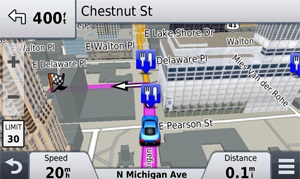
3D building data is most commonly present in major urban areas, but will not be available for all buildings in all cities. It is also only available on preloaded map data; the device will not receive 3D building data in separately purchased maps, whether on an SD card or as downloadable content.
Source:
EDIT: I was too slow.
-
The Following 1 Users Say Thank You to Genius3 For This Useful Post:
- [ Click To Expand ]
-
MickeyMouse01 (1st November 2019)
-
22nd November 2019, 08:57 PM #86
Hi
Which JCV files do I need for my Nuvi 65?
D6136100A.jcv and D6166100A.jcv?
-
22nd November 2019, 10:32 PM #87
City Navigator Europe NTU 2020.20
PreProgrammedLaneAssistTemplatePortraitWVGA (Nuvi 6x (e.g. Nuvi 65, 66), Drive 60/70, StreetPilot Android)
------------------------------
D6164100A.jcv -> JCV All North
D6135100A.jcv -> JCV All South
------------------------------
Raster Junction Views
Pictures size: 353*390
P.S. Find these JCV files: Torrent, post #24
-
The Following 1 Users Say Thank You to Genius3 For This Useful Post:
- [ Click To Expand ]
-
laci643 (23rd November 2019)
-
23rd November 2019, 04:35 PM #88
Where can I please find an img. file not max 5 gb within all europe unlocked ? I can't use on my gps the one posted because it's divided in2 parts (north and south). Thanks in advance for any help.
-
23rd November 2019, 05:04 PM #89
-
The Following 2 Users Say Thank You to FireFox58 For This Useful Post:
- [ Click To Expand ]
-
-
27th December 2019, 01:02 AM #90

City Navigator Europe NTU 2020.20
Instructions
If we copy the map into internal memory, rename the file with the name 'gmapprom.img'
If we put it in the external memory, you must create a folder and put the name of Garmin, and in it we put the IMG files of the map or maps 'gmapsupp.img'.
Garmin / gmapprom.img for internal memory
Garmin / gmapsupp.img for external memory
To select the new map:
Start / configuration / map / map info and 'mark' only the new map 2020.20
Thanks to: funcy2 and nykyLast edited by xuromi; 29th December 2019 at 03:22 AM. Reason: part 8 add


 Register To Reply
Advertisements

Suggested Articles:


 Staff Online
JetMouse Garmin Keygen v1.5 with...
No links working