


Results 1 to 10 of 35
-
23rd November 2014, 04:53 AM #1
 Garmin Expert
Supporter

 TOPO Australia & New Zealand v6
TOPO Australia & New Zealand v6
FID: 3550
Get enhanced topographic detail on your compatible device whether you're in the outback or on a main boulevard in the city. This map provides a wide array of topographic information from terrain contours, elevations and summits to coverage of perennial and intermittent lakes, rivers and streams in Australia and New Zealand.
- Provides terrain contours and summit points at 10 m intervals for a more detailed view of the terrain
- Contains more than 105,000 km of tracks, roads and outback trails; also displays 4WD destinations and hydrographic features: lake/river shorelines and perennial and seasonal streams
- Includes built-in DEM data with 3-D shading and route elevation profiles on compatible devices so you can estimate terrain difficulty
- Offers updated and new searchable points of interest in urban, rural and outback areas, including lodging, restaurants, homesteads, parks, shopping and more than 4,000 camping locations
- Displays updated routable road content, by HERE, to give you turn-by-turn directions to your destination
- (DVD only) Includes BaseCamp software, allowing you to view, manage and transfer waypoints, routes and tracks on your computer and GPS
Coverage
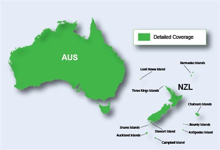
Features digital topographic and street maps for all of Australia and New Zealand. Also includes expanded coverage for several New Zealand islands, including Antipodes, Auckland, Bounty, Campbell, Kermadec, Chatham, Lord Howe, Snares, Stewart and Three Kings.
Locked Image:
PiEtU Reviewed by PiEtU on . TOPO Australia & New Zealand v5 TOPO Australia & New Zealand v6 FID: 3550 Get enhanced topographic detail on your compatible device whether you're in the outback or on a main boulevard in the city. This map provides a wide array of topographic information from terrain contours, elevations and summits to coverage of perennial and intermittent lakes, rivers and streams in Australia and New Zealand. Provides terrain contours and summit points at 10 m intervals for a more detailed view of the terrain Rating: 5Last edited by PiEtU; 8th December 2021 at 04:22 AM.
-
The Following 3 Users Say Thank You to PiEtU For This Useful Post:
- [ Click To Expand ]
-
celeps (15th May 2019), Piriguinito (13th January 2020), SS_Dave (6th October 2018)
-
5th May 2018, 07:27 AM #2
Australian and New Zealand TOPO V6 has just been released. Does anyone have a kit they could upload?
-
17th October 2018, 07:35 AM #3
-
17th October 2018, 08:40 AM #4
[QUOTE=Sharedmaps.IMG;337817]Are you volunteering to seed it? because my job is only to transfer it to one other person, and then the torrent client here goes bye bye.
I'll seed it if you have V6.
-
18th October 2018, 06:53 AM #5

.............................................................................................
Last edited by Akyta; 13th April 2019 at 11:44 AM.
-
20th October 2018, 12:18 AM #6
I am loocking for V5 or V6. Does anyone have a link?
-
20th October 2018, 12:55 AM #7

Garmin Topo Australia & New Zealand v5
or
inside
gmapsupp.img - 3,32 GB
gmapsupp-lite.img - 1,36 GB
NOTE: .IMG files untouched (original locked)
Thanks to @Akyta
-
The Following 2 Users Say Thank You to Genius3 For This Useful Post:
- [ Click To Expand ]
-
Kirsche81 (20th October 2018), Piriguinito (13th January 2020)
-
29th October 2018, 12:51 AM #8
For V6 I arranged to send a DVD physically to someone who posted in this thread. The rest will be up to him.
It’s probably best for him to start another thread for it. This is a sock puppet account that is going to sleep now.
-
30th November 2018, 06:00 AM #9
Any updates on the Topo Australia V6??
-
18th March 2019, 05:32 PM #10
Id love to try TopoV6 how does it compare to Oztopo ? anyone have the most recent versions of both Garmin TopoV6 and Oztopo ? Maybe link them on MegaNZ. I try them for a while then buy them when I get a new GPS unit.


 Register To Reply
Advertisements

Suggested Articles:


 Staff Online
iGO Primo NextGen 9.19.2.543580
linkler çökmüş. Yenileyebilirmisiniz In ENGISH...