


Results 1 to 10 of 15
-
22nd March 2014, 07:58 PM #1
 Garmin Master

 BlueChart g2 Vision - VEU704L - France 2014.0 (15.50)
BlueChart g2 Vision - VEU704L - France 2014.0 (15.50)
Part Number: MixroSD/SD (010-C0851-00), Download (010-D0431-00)
See your vessel’s precise, on-chart position in relation to navaids, coastal features, restricted areas and more with premium features found in this detailed marine mapping data. Includes all of the BlueChart® g2 features, plus 3-D perspective above and below the waterline, Auto Guidance, high-resolution imagery, and aerial photos of ports, harbors, marinas, landmarks and other points of interest.
- Includes realistic navigation features showing everything from shaded depth contours and coastlines to spot soundings, navaids, port plans, wrecks, obstructions, intertidal zones, restricted areas, IALA symbols and more.
- Features smooth displays, including seamless transitions between zoom levels and more continuity across chart boundaries.
- Includes high-resolution satellite imagery, when overlaid on the chart, provides the mariner with a realistic view of the land and water for unparalleled situational awareness.
- Features aerial “real world” photos of ports, harbors, marinas, waterways, navigational landmarks and other points of interest, offering the mariner another powerful tool for navigating unfamiliar waters.
- Includes Auto Guidance technology that searches chart data - tides, currents, marine services, coastal roads and points of interest - to suggest the best passage to a destination.
- Offers MarinerEye view 3-D perspective, providing a bird's eye view from behind the boat showing the chart information for a quick, reliable and easy position fix.
- Offers FishEye view 3-D perspective, providing an underwater view that visually represents the sea floor according to the chart's information.
- Provides Safety Shading (in compatible units), allowing mariners to enable contour shading for all depth contours shallower than user-defined safe depths.
- Provides Fishing Charts (in compatible units), allowing mariners to scope out bottom contours and depth soundings with less visual clutter on the display.
- Allows users to conveniently plan and organize routes, from your computer, before your trip with HomePort™, compatible trip-planning software (sold separately).
Coverage
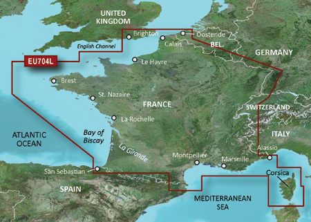
Detailed coverage of both the France Atlantic and Mediterranean coasts including Corsica. Atlantic coverage includes the English Channel coast from the French-Belgian border to Brest, Fr. and from Ramsgate through Littlehampton along the British coast. Detailed coverage also includes the French coast along the Bay of Biscay to San Sebastian, Sp. Coverage includes the entire French Mediterranean coast from Islas Medas, Spain to the Alassio, It. Coverage includes the island of Corsica in full as well as the northern tip of Sardinia.
FID: 3248, PID: 1, RID: 4, VID: 10
Locked Image:
UnLocked Image:
 p33dro Reviewed by p33dro on . BlueChart g2 Vision - VEU704L - France 2014.0 (15.50) BlueChart g2 Vision - VEU704L - France 2014.0 (15.50) Part Number: MixroSD/SD (010-C0851-00), Download (010-D0431-00) See your vessel’s precise, on-chart position in relation to navaids, coastal features, restricted areas and more with premium features found in this detailed marine mapping data. Includes all of the BlueChart® g2 features, plus 3-D perspective above and below the waterline, Auto Guidance, high-resolution imagery, and aerial photos of ports, harbors, marinas, landmarks and Rating: 5When nothing goes right, go left.
-
25th July 2016, 08:39 PM #2
invalid links

-
6th April 2017, 07:12 PM #3
seems that all link to all the map are now invalid.........
-
24th February 2018, 02:33 PM #4
Salut les liens sont mort
-
24th July 2018, 09:14 PM #5
please reupload,thank you
-
25th May 2019, 04:35 AM #6

Re-uploaded the unlocked .img file split over 500Mb .rar files to zippyshare site.
Uploaded .rar files set to private during upload to file sharing site and requires
password to unpack. Do not share or post URL to other sites.
password=gpsurl
Unlocked map files
VEU704L
Enjoy.Last edited by dennisolof; 25th May 2019 at 04:42 AM.
-
The Following 1 Users Say Thank You to dennisolof For This Useful Post:
- [ Click To Expand ]
-
loubihan (6th December 2019)
-
20th July 2020, 02:29 PM #7
please reupload,thank you
-
27th March 2021, 09:59 PM #8
Re-uploaded this release
Enjoy.
-
The Following 2 Users Say Thank You to dennisolof For This Useful Post:
- [ Click To Expand ]
-
-
24th April 2022, 10:16 PM #9
Hi dennisolof, could you please re-upload this chart again
 ?? Many thanks
-
14th October 2022, 05:33 PM #10
Hi !
Could someone re-upload this map please ? Possibly unlocked ?


 Register To Reply
Advertisements

Suggested Articles:

Similar Threads
-
BlueChart g2 Vision - VAE003R - Taiwan 2014.0 [15.50]
By p33dro in forum Garmin ArchivesReplies: 3Last Post: 9th December 2023, 03:21 PM -
BlueChart g2 - HEU055R - Finnish Lakes 2014 [15.50]
By PiEtU in forum Garmin ArchivesReplies: 3Last Post: 5th March 2023, 05:07 PM -
BlueChart g2 Vision - VEU061R - France Inland Waters 2014.0 (15.50)
By p33dro in forum Garmin ArchivesReplies: 1Last Post: 30th August 2019, 07:27 PM -
BlueChart g2 - HEU055R - Finnish Lakes 2014 [15.50]
By PiEtU in forum Garmin MapsReplies: 1Last Post: 14th August 2014, 12:34 AM -
BlueChart g2 Vision - VEU061R - France Inland Waters 2014.0 (15.50)
By p33dro in forum Garmin MapsReplies: 0Last Post: 25th March 2014, 05:33 PM


 Staff Online
GARMIN ADDITIONS FILES (ASR, G2S,...
I'm loading EU2025.10 as a supplemental map on my...