


Results 1 to 10 of 12
-
21st December 2014, 05:17 AM #1
 Garmin Expert
Supporter

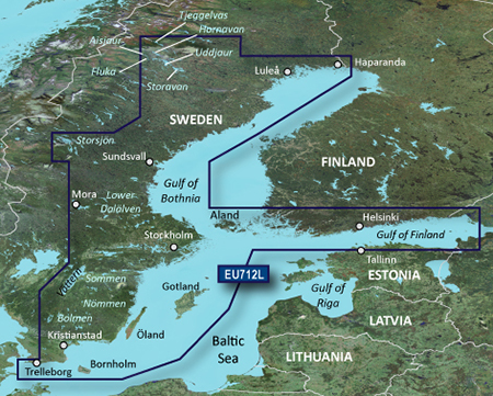
 BlueChart g2 Vision - VEU712L - Sweden East & Gulf of Finland
BlueChart g2 Vision - VEU712L - Sweden East & Gulf of Finland 2015.5 (17.00)
See your vessels precise, on-chart position in relation to navaids, coastal features and restricted areas with premium features found in this detailed marine mapping data. Includes all of the features of our BlueChart® g2 product, plus 3-D perspective above and below the waterline, Auto Guidance, high-resolution imagery, and aerial photos of ports, harbors, marinas and landmarks.
- Shaded depth contours, coastlines, spot soundings, navaids, port plans, wrecks, obstructions, intertidal zones, restricted areas and IALA symbols.
- Seamless transitions between zoom levels and more continuity across chart boundaries.
- High resolution satellite imagery for a realistic view of the land and water.
- Aerial photos of ports, harbors, marinas, waterways, navigational landmarks and other POIs.
- Auto Guidance technology searches chart data to suggest the best passage to a destination.
- MarinerEye view 3-D perspective for a quick, easy position fix.
- FishEye view 3-D perspective for an underwater view of the sea floor.
- Safety Shading* enables contour shading for all depth contours shallower than your defined safe depths.
- Fishing Charts* to scope out bottom contours and depth soundings with less visual clutter on the display.
- Plan and organize routes from your computer with HomePort (sold separately).
Coverage
Detailed coverage of the coast of Sweden along the Baltic Sea and Gulf of Bothnia from Trelleborg to Haparanda including Kristianstad, Stockholm, Sundsvall, and Luleå; also coastal coverage of Finland's Gulf of Finland from Uusikaupunki to Vyborg, RU including Turku, Hanko, and Helsinki. Swedish lake coverage features Vättern, Sommen, Nommen, Revsundssjön, Hjälmaren, Siljan, Mälaren, Storsjön, Storavan, Uddjaur, Hornovan, Tjeggelvas, Aisjaur, Fluka, Helgasjön, and Bolmen, as well as coverage of the lower Dalälven from Gysinge to Söderfors. Island coverage features Bornholm, Oland, Gotland, and Åland.
FID: 3850, PID: 1, RID: 4, VID: 18
Locked Image:
UnLocked Image:
 PiEtU Reviewed by PiEtU on . BlueChart g2 Vision - VEU712L - Sweden East & Gulf of Finland BlueChart g2 Vision - VEU712L - Sweden East & Gulf of Finland 2015.5 (17.00) See your vessels precise, on-chart position in relation to navaids, coastal features and restricted areas with premium features found in this detailed marine mapping data. Includes all of the features of our BlueChart® g2 product, plus 3-D perspective above and below the waterline, Auto Guidance, high-resolution imagery, and aerial photos of ports, harbors, marinas and landmarks. Shaded depth contours, Rating: 5
Last edited by Garmin_Nuvi; 23rd September 2020 at 05:51 AM.
-
The Following 2 Users Say Thank You to PiEtU For This Useful Post:
- [ Click To Expand ]
-
-
8th March 2020, 05:03 PM #2
download links are down
-
20th August 2020, 01:24 AM #3
-
The Following 1 Users Say Thank You to Smulan For This Useful Post:
- [ Click To Expand ]
-
Garmin_Nuvi (20th August 2020)
-
20th August 2020, 12:44 PM #4
-
22nd August 2020, 11:44 PM #5
Do you have any newer version of that map or any other including the Stockholm area?
-
22nd September 2020, 01:40 AM #6
-
The Following 1 Users Say Thank You to Smulan For This Useful Post:
- [ Click To Expand ]
-
dibblah (22nd September 2020)
-
22nd September 2020, 02:41 PM #7
Garmin g2 Vision Card: Sweden East, Jul 08 (VEU712L) (10.00)
MFG ID: 010-C0859-00
VEU712L Covers:
Detailed coverage of the Sweden coast along the Baltic Sea and Gulf of
Bothnia from Trelleborg to Haparanda, including Kristianstad, Stockholm,
Sundsvall, and Lulea. Also includes coverage of Bornholm, Oland,
Gotland, Aland, and lakes V„ttern, Hj„lmaren, M„laren, Tjeggelvas,
Hornovan, Uddjaur, Storavan, Aisjaur, Fluka, Storsj”n, Sommen, Nommen,
and Bolmen, Storsj”n, Mj”rn, Sommen, Nommen, Helgasj”n, and Bolmen, as
well as coverage of the lower Dal„lven from Gysinge to S”derfors, Swe.
Map Date: 31.12.2007
List Price $481.70
Family ID : 314
Product ID : 1
Region : 4, 18
-
24th February 2021, 06:39 PM #8

Hi All!
Any chance to have a really worked Link for this Map?

Edit:
Found the Map, Thanks to
VEU712L .rar (1.78 GB)
Password: gpsurlLast edited by FireFox58; 26th February 2021 at 01:33 PM.
-
22nd March 2021, 06:21 PM #9

Re-uploaded this release
Enjoy.
-
14th November 2021, 10:26 AM #10
Anyone feeling like updating the download links?


 Register To Reply
Advertisements

Suggested Articles:


 Staff Online
NAV2 Truck map alternatives
The missing tmeta file is the problem. Navcore...