


![BlueChart g2 - HEU008R - Bay of Biscay 2014.0 [15.50]](https://www.hostdel.com/banners/Hosting/728x90.gif)
Results 1 to 2 of 2
-
25th July 2014, 05:29 AM #1
 Garmin Expert
Supporter

 BlueChart g2 - HEU008R - Bay of Biscay 2014.0 [15.50]
BlueChart g2 - HEU008R - Bay of Biscay 2014.0 (15.50)
See your vessels precise, on-chart position in relation to navaids, coastal features, anchorages, obstructions, waterways, restricted areas and more with this detailed marine mapping data.
- Shaded depth contours, coastlines, spot soundings, navaids, port plans, wrecks, obstructions, intertidal zones, restricted areas and IALA symbols.
- Seamless transitions between zoom levels and more continuity across chart boundaries.
- Standard 2-D direct overhead or 3-D over the bow map perspective for easy chart reading and orientation.
- Safety Shading* enables contour shading for all depth contours shallower than your defined safe depths.
- Fishing Charts* to scope out bottom contours and depth soundings with less visual clutter on the display.
- Plan and organize routes from your computer with HomePort (sold separately).
Coverage
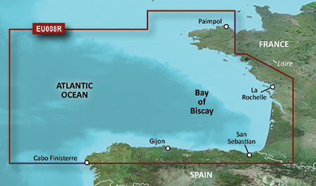
From Binic, France to Cabo Finisterre, Spain.
FID: 3256, PID: 1, RID: 2, VID: 14
Locked Image:
UnLocked Image:
 PiEtU Reviewed by PiEtU on . BlueChart g2 - HEU008R - Bay of Biscay 2014.0 [15.50] BlueChart g2 - HEU008R - Bay of Biscay 2014.0 (15.50) See your vessels precise, on-chart position in relation to navaids, coastal features, anchorages, obstructions, waterways, restricted areas and more with this detailed marine mapping data. Shaded depth contours, coastlines, spot soundings, navaids, port plans, wrecks, obstructions, intertidal zones, restricted areas and IALA symbols. Seamless transitions between zoom levels and more continuity across chart boundaries. Rating: 5
-
25th March 2021, 08:49 PM #2

Re-uploaded this release
Enjoy.
-
The Following 1 Users Say Thank You to dennisolof For This Useful Post:
- [ Click To Expand ]
-
ta1234 (18th June 2021)
![BlueChart g2 - HEU008R - Bay of Biscay 2014.0 [15.50]](https://www.hostdel.com/banners/RDP/300X250.gif)

 Register To Reply
Advertisements
![BlueChart g2 - HEU008R - Bay of Biscay 2014.0 [15.50]](https://www.hostdel.com/banners/Dedicated/728x90.gif)
Suggested Articles:
![BlueChart g2 - HEU008R - Bay of Biscay 2014.0 [15.50]](https://www.hostdel.com/banners/GameServer/728x90.gif)

![BlueChart g2 - HEU008R - Bay of Biscay 2014.0 [15.50]](https://www.hostdel.com/banners/Email/300X250.gif)


 Staff Online
![BlueChart g2 - HEU008R - Bay of Biscay 2014.0 [15.50]](https://www.hostdel.com/banners/Dedicated/300x600.gif)
GARMIN ADDITIONS FILES (ASR, G2S,...
Where they reside on the device was answered in...