


![BlueChart g2 Vision - VPC410S - Esperance-Exmouth Bay 2014.0 [15.50]](https://www.hostdel.com/banners/Hosting/728x90.gif)
Results 1 to 1 of 1
-
29th March 2014, 04:52 AM #1
 Garmin Master

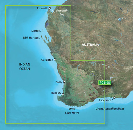
 BlueChart g2 Vision - VPC410S - Esperance-Exmouth Bay 2014.0 [15.50]
BlueChart g2 Vision - VPC410S - Esperance-Exmouth Bay 2014.0 (15.50)
See your vessels precise, on-chart position in relation to navaids, coastal features and restricted areas with premium features found in this detailed marine mapping data. Includes all of the features of our BlueChart® g2 product, plus 3-D perspective above and below the waterline, Auto Guidance, high-resolution imagery, and aerial photos of ports, harbors, marinas and landmarks.
- Shaded depth contours, coastlines, spot soundings, navaids, port plans, wrecks, obstructions, intertidal zones, restricted areas and IALA symbols.
- Seamless transitions between zoom levels and more continuity across chart boundaries.
- High resolution satellite imagery for a realistic view of the land and water.
- Aerial photos of ports, harbors, marinas, waterways, navigational landmarks and other POIs.
- Auto Guidance technology searches chart data to suggest the best passage to a destination.
- MarinerEye view 3-D perspective for a quick, easy position fix.
- FishEye view 3-D perspective for an underwater view of the sea floor.
- Safety Shading* enables contour shading for all depth contours shallower than your defined safe depths.
- Fishing Charts* to scope out bottom contours and depth soundings with less visual clutter on the display.
- Plan and organize routes from your computer with HomePort (sold separately).
Coverage
Detailed coverage of the Southwest coast of Australia from Esperance to Dorre Island and Exmouth Bay. Detailed coverage of Geraldton, Perth, and Bunbury also included.
FID: 3249, PID: 1, RID: 5, VID: 21
Locked Image:
UnLocked Image:
 p33dro Reviewed by p33dro on . BlueChart g2 Vision - VPC410S - Esperance-Exmouth Bay 2014.0 [15.50] BlueChart g2 Vision - VPC410S - Esperance-Exmouth Bay 2014.0 (15.50) See your vessels precise, on-chart position in relation to navaids, coastal features and restricted areas with premium features found in this detailed marine mapping data. Includes all of the features of our BlueChart® g2 product, plus 3-D perspective above and below the waterline, Auto Guidance, high-resolution imagery, and aerial photos of ports, harbors, marinas and landmarks. Shaded depth contours, coastlines, Rating: 5When nothing goes right, go left.
![BlueChart g2 Vision - VPC410S - Esperance-Exmouth Bay 2014.0 [15.50]](https://www.hostdel.com/banners/RDP/300X250.gif)

 Register To Reply
Advertisements
![BlueChart g2 Vision - VPC410S - Esperance-Exmouth Bay 2014.0 [15.50]](https://www.hostdel.com/banners/Dedicated/728x90.gif)
Suggested Articles:
![BlueChart g2 Vision - VPC410S - Esperance-Exmouth Bay 2014.0 [15.50]](https://www.hostdel.com/banners/GameServer/728x90.gif)
Similar Threads
-
BlueChart g2 Vision - VUS009R - Jacksonville-Key West 2014 [15.50]
By PiEtU in forum Garmin MapsReplies: 4Last Post: 12th April 2023, 11:08 PM -
BlueChart g2 Vision - VEU061R - France Inland Waters 2014.0 (15.50)
By p33dro in forum Garmin ArchivesReplies: 1Last Post: 30th August 2019, 07:27 PM -
BlueChart g2 - HPC410S - Esperance-Exmouth Bay 2014.0 [15.50]
By p33dro in forum Garmin ArchivesReplies: 1Last Post: 27th May 2019, 08:27 AM -
BlueChart g2 Vision - VPC410S - Esperance-Exmouth Bay 2014.0 [15.50]
By p33dro in forum Garmin MapsReplies: 0Last Post: 29th March 2014, 04:52 AM -
BlueChart g2 - HPC410S - Esperance-Exmouth Bay 2014.0 [15.50]
By p33dro in forum Garmin MapsReplies: 0Last Post: 29th March 2014, 04:00 AM

![BlueChart g2 Vision - VPC410S - Esperance-Exmouth Bay 2014.0 [15.50]](https://www.hostdel.com/banners/Email/300X250.gif)


 Staff Online
![BlueChart g2 Vision - VPC410S - Esperance-Exmouth Bay 2014.0 [15.50]](https://www.hostdel.com/banners/Dedicated/300x600.gif)
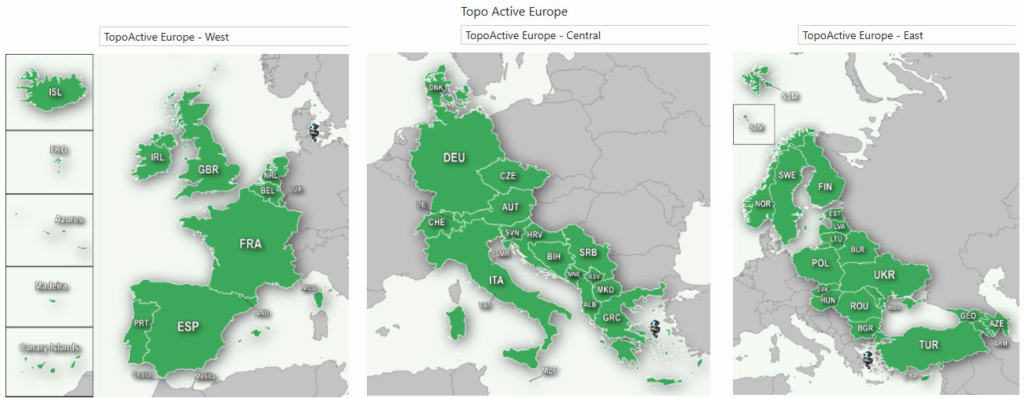
TopoActive Europe 2024.10 FID 12522
TopoActive Europe 2024.10, West (D6185140A) ...