


Results 1 to 2 of 2
-
25th March 2014, 05:33 PM #1
 Garmin Master

 BlueChart g2 Vision - VEU061R - France Inland Waters 2014.0 (15.50)
BlueChart g2 Vision - VEU061R - France Inland Waters 2014.0 (15.50)
See your vessels precise, on-chart position in relation to navaids, coastal features, restricted areas and more with premium features found in this detailed marine mapping data. Includes all of the BlueChart® g2 features, plus 3-D perspective above and below the waterline, Auto Guidance, high-resolution imagery, and aerial photos of ports, harbors, marinas, landmarks and other points of interest.
- Includes realistic navigation features showing everything from shaded depth contours and coastlines to spot soundings, navaids, port plans, wrecks, obstructions, intertidal zones, restricted areas, IALA symbols and more.
- Features smooth displays, including seamless transitions between zoom levels and more continuity across chart boundaries.
- Includes high-resolution satellite imagery, when overlaid on the chart, provides the mariner with a realistic view of the land and water for unparalleled situational awareness.
- Features aerial real world photos of ports, harbors, marinas, waterways, navigational landmarks and other points of interest, offering the mariner another powerful tool for navigating unfamiliar waters.
- Includes Auto Guidance technology that searches chart data - tides, currents, marine services, coastal roads and points of interest - to suggest the best passage to a destination.
- Offers MarinerEye view 3-D perspective, providing a bird's eye view from behind the boat showing the chart information for a quick, reliable and easy position fix.
- Offers FishEye view 3-D perspective, providing an underwater view that visually represents the sea floor according to the chart's information.
- Provides Safety Shading (in compatible units), allowing mariners to enable contour shading for all depth contours shallower than user-defined safe depths.
- Provides Fishing Charts (in compatible units), allowing mariners to scope out bottom contours and depth soundings with less visual clutter on the display.
- Allows users to conveniently plan and organize routes, from your computer, before your trip with HomePort, compatible trip-planning software (sold separately).
Coverage
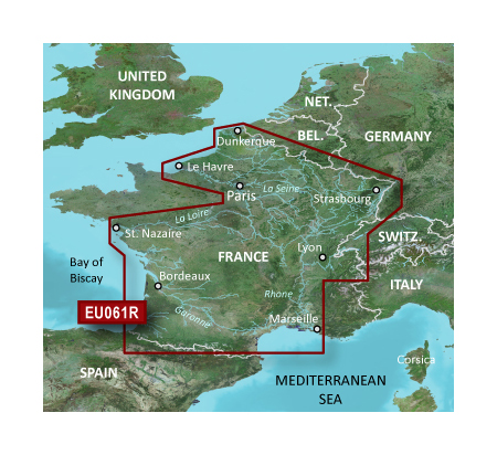
Detailed coverage of coastal and interior France including the coast from Marseille to St. Cyprien, Bayonne to St-Nazaire and La Havre to Dunkirk. Coverage of interior waterways include the Adour, Garonne, Charente, Loire, Seine and Rhone River systems. The Sevre-Nantaise, Somme, Meuse, Moselle, and Saone Rivers, the Rhine from Basel, CH to Karlsruhe, DE; Lake Leman (Geneva), Lake Neuchatel, Lake Biel, Lake Morat, the Canal du Midi, the Canal du Centre and the Rhine-Rhone Canal are also covered.
FID: 3247, PID: 1, RID: 17, VID: 5
Locked Image:
UnLocked Image:
 p33dro Reviewed by p33dro on . BlueChart g2 Vision - VEU061R - France Inland Waters 2014.0 (15.50) BlueChart g2 Vision - VEU061R - France Inland Waters 2014.0 (15.50) See your vessels precise, on-chart position in relation to navaids, coastal features, restricted areas and more with premium features found in this detailed marine mapping data. Includes all of the BlueChart® g2 features, plus 3-D perspective above and below the waterline, Auto Guidance, high-resolution imagery, and aerial photos of ports, harbors, marinas, landmarks and other points of interest. Includes realistic Rating: 5When nothing goes right, go left.
-
30th August 2019, 07:27 PM #2
Hello
would anyone have a valid link for the VEU061R - France Inland Waters ?
thank you


 Register To Reply
Advertisements

Suggested Articles:

Similar Threads
-
BlueChart g2 Vision - VEU704L - France 2014.0 (15.50)
By p33dro in forum Garmin MapsReplies: 14Last Post: 23rd January 2024, 08:10 PM -
BlueChart g2 Vision - VAE009R - Sin/Mal/Indonesia 2014.0 [15.50]
By p33dro in forum Garmin MapsReplies: 12Last Post: 2nd June 2023, 07:03 AM -
BlueChart g2 Vision - VUS009R - Jacksonville-Key West 2014 [15.50]
By PiEtU in forum Garmin MapsReplies: 4Last Post: 12th April 2023, 11:08 PM -
BlueChart g2 Vision - VPC018R - New Caledonia-Fiji 2014.0 [15.50]
By p33dro in forum Garmin ArchivesReplies: 1Last Post: 26th March 2021, 06:34 PM -
BlueChart g2 Vision - VEU061R - France Inland Waters 2014.0 (15.50)
By p33dro in forum Garmin MapsReplies: 0Last Post: 25th March 2014, 05:33 PM


 Staff Online
iGO Primo NextGen 9.19.2.543580
linkler çökmüş. Yenileyebilirmisiniz