


![BlueChart g2 - HEU704L - France 2014.0 [15.50]](https://www.hostdel.com/banners/Hosting/728x90.gif)
Results 1 to 1 of 1
-
22nd March 2014, 08:39 AM #1
 Garmin Master

 BlueChart g2 - HEU704L - France 2014.0 [15.50]
BlueChart g2 - HEU704L - France 2014.0 (15.50)
Part Number: GarminCard (010-C0851-10), MicroSD/SD (010-C0851-20), Download (010-D0583-00)
See your vessels precise, on-chart position in relation to navaids, coastal features, anchorages, obstructions, waterways, restricted areas and more with this detailed marine mapping data.
- Shaded depth contours, coastlines, spot soundings, navaids, port plans, wrecks, obstructions, intertidal zones, restricted areas and IALA symbols.
- Seamless transitions between zoom levels and more continuity across chart boundaries.
- Standard 2-D direct overhead or 3-D over the bow map perspective for easy chart reading and orientation.
- Safety Shading* enables contour shading for all depth contours shallower than your defined safe depths.
- Fishing Charts* to scope out bottom contours and depth soundings with less visual clutter on the display.
- Plan and organize routes from your computer with HomePort (sold separately).
Coverage
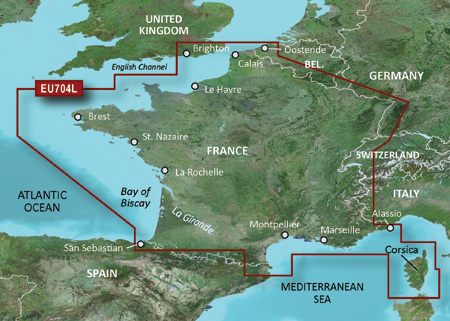
Detailed coverage of the French Atlantic and Mediterranean coasts, the interior waterways of France and the island of Corsica. Atlantic coverage includes the British coast from Ramsgate to Brighton. Detailed coverage includes the Channel Islands, major French canals including the Canal du Centre and the Rhine-Rhone Canal, Lake Leman (Geneva) and the Garonne, Loire, Seine and Rhone River systems and the Rhine River from Basle, CH to Karlsruhe, DE.
FID: 3257, PID: 1, RID: 4, VID: 10
Locked Image:
UnLocked Image:
 p33dro Reviewed by p33dro on . BlueChart g2 - HEU704L - France 2014.0 [15.50] BlueChart g2 - HEU704L - France 2014.0 (15.50) Part Number: GarminCard (010-C0851-10), MicroSD/SD (010-C0851-20), Download (010-D0583-00) See your vessels precise, on-chart position in relation to navaids, coastal features, anchorages, obstructions, waterways, restricted areas and more with this detailed marine mapping data. Shaded depth contours, coastlines, spot soundings, navaids, port plans, wrecks, obstructions, intertidal zones, restricted areas and IALA symbols. Seamless Rating: 5When nothing goes right, go left.
![BlueChart g2 - HEU704L - France 2014.0 [15.50]](https://www.hostdel.com/banners/RDP/300X250.gif)

 Register To Reply
Advertisements
![BlueChart g2 - HEU704L - France 2014.0 [15.50]](https://www.hostdel.com/banners/Dedicated/728x90.gif)
Suggested Articles:
![BlueChart g2 - HEU704L - France 2014.0 [15.50]](https://www.hostdel.com/banners/GameServer/728x90.gif)
Similar Threads
-
BlueChart g2 - HEU055R - Finnish Lakes 2014 [15.50]
By PiEtU in forum Garmin ArchivesReplies: 3Last Post: 5th March 2023, 05:07 PM -
BlueChart g2 - HEU704L - France 2015.0 [16.50]
By PiEtU in forum Garmin ArchivesReplies: 2Last Post: 25th March 2021, 04:21 PM -
BlueChart g2 - HEU704L - France 2015.0 [16.50]
By PiEtU in forum Garmin MapsReplies: 1Last Post: 6th September 2015, 06:19 PM -
BlueChart g2 - HAE003R - Taiwan 2014.0 [15.50]
By p33dro in forum Garmin ArchivesReplies: 0Last Post: 25th March 2014, 10:16 PM -
BlueChart g2 - HEU704L - France 2014.0 [15.50]
By p33dro in forum Garmin MapsReplies: 0Last Post: 22nd March 2014, 08:39 AM

![BlueChart g2 - HEU704L - France 2014.0 [15.50]](https://www.hostdel.com/banners/Email/300X250.gif)


 Staff Online
![BlueChart g2 - HEU704L - France 2014.0 [15.50]](https://www.hostdel.com/banners/Dedicated/300x600.gif)
City Navigator North America NT...
I downloaded all 3. 1 and 2 show there is...